Bikes Lanes
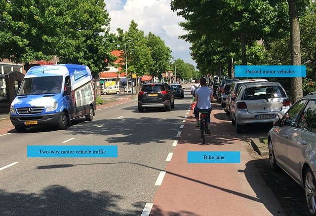
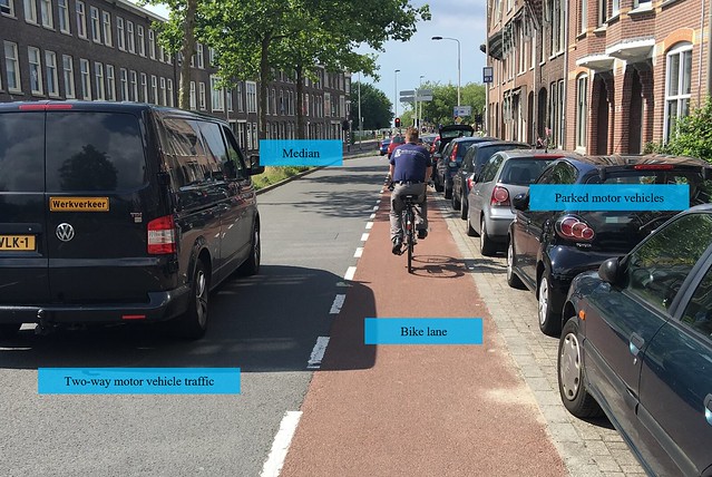
Bikes lanes, and especially the ones on Nassaulaan and Julianalaan, definitely make me feel less safe than on other types of bicycle infrastructure. This is mainly due to the presence of parked cars directly next to the bike lanes with no buffer for car doors to be opened safely, along with motor vehicle traffic passing by. I would assume that most Dutch drivers and cyclists would be educated and aware enough to avoid most danger, but the hazards do exist. Still, a bike line is certainly much better than no separated area on busy streets for cyclists, and the cheapness of this solution makes it preferable in some cases. However, I am glad the overall Dutch attitude toward bike lanes is negative and that planners are encouraged to avoid them when possible.
Nassaulaan utilizes every inch of space on the somewhat busy road, but the risk of “dooring” and falling into oncoming traffic is a real threat on this road and all roads with similar designs.
Julianalaan is similar to Nassaulaan in its risks except that a median separates the lanes of oncoming traffic. Perhaps the space for the median could best serve as a buffer between the bike lane and the parked vehicles?
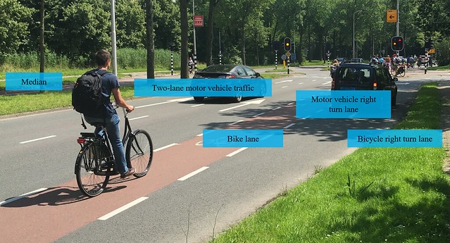
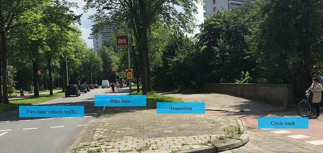
Out of all the bike lanes that were observed, this one (Buitenhofdreef) stood out to me as the most well thought-out. The right turn lanes for both bicycles and motor vehicles are designed to make it safer for cyclists and the absence of vehicle parking eliminates the risk of “dooring” completely. Although bike lanes on a two lane road do not seem like the best scenario, the faster traffic would most likely be in the left lane, away from cyclists.
Bike Boulevard
Likely just as cheap as bike lanes, bike boulevards accommodate cyclists simply by banning or discouraging non-local motor or non-mass transit vehicle traffic. Overall a better cheap option than the similarly cost-effective bike lanes, when a city can manage the diversion of motor vehicles from a road, bike boulevards a very viable and cheap option.
The Buitenwatersloot bike boulevard enables an historic area to maintain part of its original look and feel without having to drastically change in order to continue to serve as a main road for motor vehicles. Instead, the cheap option of simply changing the pavement markings and blocking the area off to vehicle traffic was chosen in order to cater more to bicycles and give vehicles an overall better option somewhere else.
Cycle Tracks
Cycle tracks seem to be the most common and most preferred form of bicycle infrastructure in the Netherlands. Although they requires more time, money, and space, they set the standard for the quality, safety, and stress-free Dutch bicycle networks. Varying from one to two lanes, they each have their positive and negative attributes, but I find that two lane cycle tracks seem to work best since it eliminates the possibility of traveling on the wrong path and also provides more space for passing.
On Ruys de Beerenbrouckstraat, one lane cycle paths on either side are diverted from turning cars in order to give them enough space to make a full turn before crossing the track.
Papsouwselaan has a transition from a cycle track to a bike lane. Although I feel like cycling would be more prevalent on such a long street and an an extended cycle track would better serve the community than a larger sidewalk, I do not know the exact circumstances for this decision.
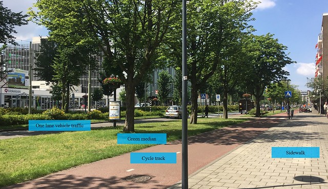
Voorhofdreef is an extremely interesting collection of roads, bike paths, and public transit lines. Giving the two-lane cycle track and the pedestrian sidewalk easy access to the shops allows for more customers while the one lane road ensures safe speeds for bikes and pedestrians crossing the street. The tram line going down the middle also extends the usage of the boulevard even more.
Advisory Lanes
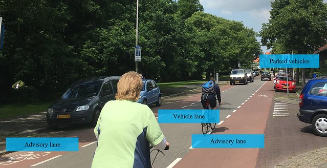
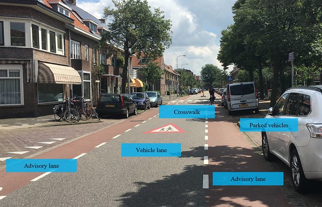
Advisory lanes, although on paper they seem to be a crazy idea, work surprisingly well. It enables bike lanes to exist in streets that otherwise would not be able to fit them without major changes to the area and is also extremely cheap, comparable to regular bike lanes. However, they carry the same risks as bike lanes. Also, how would planners deal with curves or areas with limited visibility with these types of roads?
On Adriaan Pauwstraat, there is no separation between the parked cars and the advisory lanes. Maybe in this case it would be a good idea to advise drivers to park facing the oncoming bike traffic in order to always have the oncoming cyclists in sight to avoid “dooring”?
Hugo de Grootstraat is very similar to Adriaan Pauwstraat, except parking right next to the advisory lanes is even more prevalent and more shopping destinations are present.
On Molenweg, no parking exists along the advisory lanes and occasional speed humps slow down traffic.
Bicycle Highway
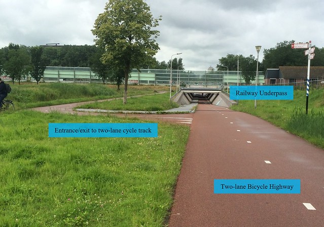
This alternative form of a cycle track enables cyclists to travel long distances uninterrupted by intersections or any other obstructions.
In the case of the N470 bike highway pictured above, it even has its own underpass under the railway that would otherwise obstruct it. An exit/entrance to a two line cycle track is also pictured.
This type of bicycle infrastructure, although expensive on its own, is likely much cheaper than the re-arranging of already existing roads. It also enables commuters who travel longer distances to and from Delfgauw to have a faster and more relaxing journey. However, moped riders seemed to take advantage of this situation and traveled even faster than they normally do on other types of bicycle infrastructure. Personally, I felt like I was travelling much faster than I would be on a different type of cycle track and enjoyed the complete independence from any vehicles. I also appreciated the time, money, and effort that went into the underpass in particular in order to make cyclists’ lives easier.

